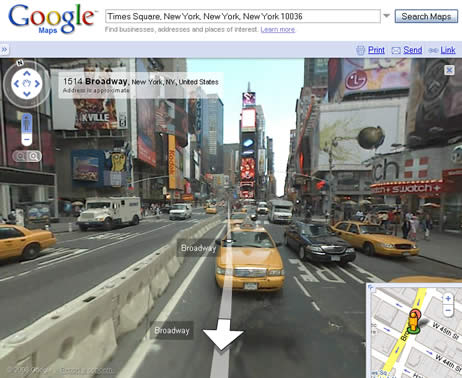
Google Street View
Google Street View is a feature in Google Map that allows users to explore streets around the world in a 360-degree panoramic view. First launched in the United States on May 25th, 2007, it is now developing at a rapid rate in different countries around the world. This technology lets people check out travel sites, restaurants, neighborhoods from different angles, in a multi-dimentional view. The images in Google Street View are captured by cars specially adapted with cameras and antennas, also by tricycles and snowmobiles at places where cars cannot easily access.

Contents
Timeline
| Date | Key Development |
|---|---|
| December 25, 2007 | Google lauches Google Street View |
| May 12, 2008 | Google first announced its success with testing face-blurring technology on its photographs of the streets of Manhattan. |
| April 16, 2008 | Google Street View became a part of Google Earth 4.3 |
Processing Imagery
Google Street View is first created by collecting photographs of desired locations, which is done by moving vehicles equipped with cameras and antennas. While capturing pictures, photographers need to pay close attention to the position of the sun, so the contour of the landmarks do not blur in the shadows. They also need to consider other factors like weather and temperature.
Photographers plan to collect images starting with places that tend to be more populated and important.
Turning Photographs into Street View
Multiple cameras on the vehicles take overlapping pictures so there are no gaps in the 360-degree Street View. Each picture is analyzed on the angle and distance that it was taken from. Then the separate photographs are pieced together into a unified panorama like the pictures below.
Separate photographs:
Unified panorama:
Google Street View as users see it:
Technology
Images are captured primarily by specially fitted vehicles that drive around collecting images. Imaging trips are carefully planned in terms of time of day, time of year, and weather. There can be no snow, fog, rain, or shadows because that will skew the images. They also take into account traffic so as to utilize their time most efficiently.
In order to determine which images align with which addresses, they use signals from sensors around the imaging vehicle, GPS, as well as speed and direction monitors. Additionally, they use image blurring software to make sure pedestrians' faces and vehicles' license plates are not visible. [1]
Areas of Coverage
| Continent | Country | Year added |
|---|---|---|
| North America | United States | 2007 |
| Canada | 2009 | |
| Mexico | 2009 | |
| South America | Brazil | 2010 |
| Europe | Belgium | 2011 |
| Czech Republic | 2009 | |
| Denmark | 2010 | |
| France | 2008 | |
| Finland | 2010 | |
| Germany | 2010 | |
| Ireland | 2010 | |
| Italy | 2008 | |
| Isle of Man | 2011 | |
| Jersey | 2011 | |
| Monaco | 2011 | |
| Netherlands | 2009 | |
| Norway | 2010 | |
| Portugal | 2009 | |
| Romania | 2010 | |
| Spain | 2008 | |
| Sweden | 2010 | |
| Switzerland | 2009 | |
| United Kingdom | 2009 | |
| Asia | Hong Kong | 2010 |
| Japan | 2008 | |
| Macau | 2010 | |
| Malaysia | 2011 | |
| Singapore | 2009 | |
| Taiwan | 2009 | |
| Thailand | 2011 | |
| Australia | Australia | 2008 |
| New Zealand | 2008 | |
| Africa | South Africa | 2009 |
| Antartica | Antartica | 2010 |
Ethical Dilemma
As Google's Street View project continues to progress, it continues to face a variety of legal barriers and a large public outcry over ethical issues. Some individuals praise the newest technological innovation by Google for its convenience it has created. On the other hand, there are others who claim it violates an individuals right to privacy.
Data Collection
In June of 2011, a federal judge ruled that Google could be held responsible, and sued, for secretly collecting data on open WiFi Networks. [2]. Google became aware of their data collection after an audit was requested by Hamburg, Germany's data protection authority and have since ceased their wifi collection [3].
Privacy Issues
Even though Google Street View has the purpose of providing users a realistic and visual appealing panoramic view of geographic areas, many privacy concerns were raised at some of the photos taken by the Google vehicles. Pictures taken of individuals or groups who do not want to be photographed and released to the public. For example, political protesting crowds, women sun-bathing out on their lawns, men coming out of strip clubs.
Google Inc. has made efforts to address the privacy concerns by offering a "help" button next to all the public pictures that allow users to request removal of controversial pictures taken. [4]
References
- ↑ http://maps.google.com/help/maps/streetview/technology/photos-into-street-view.html Retrieved 21 November 2011.
- ↑ Kravets, David. "Judge: Google Can Be Sued for Wiretapping in Street View Debacle". Wired Magazine. June 30, 2011. Web.
- ↑ McMillan, Robert. "Google stops sniffing Wi-Fi data after privacy gaffe". Computerworld March 14 2010. Web.
- ↑ Google. (2011). Corporate information. Retrieved from http://www.google.com/about/corporate/company/


