Difference between revisions of "Waze"
| Line 122: | Line 122: | ||
===Traffic=== | ===Traffic=== | ||
| − | Like many GPS applications, Waze is able to detect traffic and redirect drivers to a different route to avoid the traffic. It finds the route that takes the shortest amount of time for drivers to get to a destination. However, this has led to concerns about an excessive inflation of traffic for certain roads, especially local roads. [[wikipedia:Leonia|A town in New Jersey]] closed down its roads to non-residents during rush hours because of issues with increased traffic from commuters being redirected by Waze to get to New York City faster. <ref> Shkolnikova, Svetlana Leonia road closures: 60 residential streets closed to commuters Monday morning. [https://www.northjersey.com/story/news/bergen/leonia/2018/01/22/leonia-road-closures-60-residential-streets-closed-commuters-morning/1050586001/] 22 January 2018. Retrieved 12 April 2018 </ref> Locals have complained that GPS applications like Waze have been increasing traffic to | + | Like many GPS applications, Waze is able to detect traffic and redirect drivers to a different route to avoid the traffic. It finds the route that takes the shortest amount of time for drivers to get to a destination. However, this has led to concerns about an excessive inflation of traffic for certain roads, especially local roads. [[wikipedia:Leonia|A town in New Jersey]] closed down its roads to non-residents during rush hours because of issues with increased traffic from commuters being redirected by Waze to get to New York City faster. <ref> Shkolnikova, Svetlana Leonia road closures: 60 residential streets closed to commuters Monday morning. [https://www.northjersey.com/story/news/bergen/leonia/2018/01/22/leonia-road-closures-60-residential-streets-closed-commuters-morning/1050586001/] 22 January 2018. Retrieved 12 April 2018 </ref> Locals have complained that GPS applications like Waze have been increasing traffic to residents, local roads, making it difficult for residents to get to school or get to work. |
| + | |||
| + | ===Location Based Advertising=== | ||
| + | Waze recently announced that they will allow small business to buy advertising. When the vehicle is stopped, users will now be subject to branded pins, paid search results, and popups. The three types of Local ads are "takeover ads" which will appear on the top third of a user's screen when they are stopped for at least three seconds, branded pins, which will show up along a user's route, and promoted search ads, which will appear when a user is searching for something through the app. <ref>[https://www.cnbc.com/2018/03/28/google-owned-waze-launches-waze-local-ads.html]</ref>. This raises concerns regarding location-based advertising, specifically whether Waze is taking advantage of their users and their data. Although, Waze exec Matt Phillips says that throughout the past year of beta testing, there have been no reports of annoyed users. | ||
=References= | =References= | ||
Revision as of 22:05, 23 April 2018
|
Contents
History
Waze, formerly known as FreeMap Israel, began out of the frustration that co-founder Ehud Shabati had with traditional GPS systems. [2] What started as a solo project of Shabati's soon expanded to a community project to generate a free map of Israel.[3] The first round of funding came in 2008 from BlueRun Ventures and Magma Venture Partners, with the second round in 2010. FreeMap Israel changed its name to Waze in 2009. After a third round 2011 from Horizons Ventures and Kleiner Perkins Caufield & Byers, Google bought Waze in 2013.[4]
Acquisition by Google
While Facebook, Apple, and others were interested in purchasing Waze, Google acquired Waze in 2013 for $1.3 billion. [5]. The U.S. Federal Trade Commission investigated the deal as Google was already a player in the mapping market. In the end, the antitrust challenge was not aggressive enough to impact competition, and the case was dropped.[6]
Overview
Personalization
Users are able to change the display of the map, the mode (day or night), and the sound (voice) for navigation. The language, units, and events radius can also be changed depending on the user's preference. Waze also has the ability to play the navigation through the user's speaker phone or Bluetooth device. Users can update their navigation preferences to avoid toll roads, freeways, and unpaved roads, finding alternate routes to get to the same destination. Waze can also sync with a user's calendar, Facebook profile, and Twitter profile. Users can also set a preferred gas station, gas type, and then sort gas stations by distance, price, or brand.
Users can set a Home and Work address for easy, one-tap navigation, as well as updates on unusual traffic events. Users can choose a "mood" for their car which determines how they are displayed on the app if they have an account. There is an option for users to join teams, such as with local TV stations, so that their contributions are included in the morning traffic update. Users can also add their friends and communicate in different ways.
Live Traffic Updates
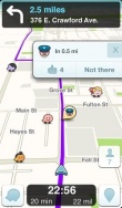
The main interface of Waze is equipped with a fully interactive map, based on the users' geolocation. When the user opens this iPhone application, the cellular phone transmits its location to the application servers, and traffic updates in real time are pulled from Waze users who are near you. This allows drivers to make decisions on their routes, based on traffic information that users have contributed recently. Although this application has communication capabilities, the map is designed well enough that the average user (someone looking to get traffic updates) can look at the map and read all necessary information without having to communicate with other users. Also, users can update other users on traffic, accidents, police cars, and potholes on the road. When a user passes that location and doesn't see a police there anymore, or the accident got cleaned up, they can update other users that it is not there anymore.
User Interaction
Users can communicate in different ways. If they are friends on Waze, they are able to send their ETA, send a "Beep Beep", call them, or send a private message. Users can also thank you by giving you a thumbs up on something you reported, as well as send a map chat. It is not required that a user be friends with a user to communicate. Rather, it depends on the other Wazers that are traveling in the same area as you.
User Contribution
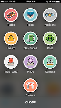
Users earn points by reporting to traffic updates. This can be done by reporting the traffic, police, an accident, a hazard on the road, gas prices, chatting, reporting map issue, taking a picture of a place, reporting a camera or a road closure. Each report is worth a different amount of points. See tables below.[7]
| Activity | Points | Unit |
|---|---|---|
| Road reporting | 6 | per report |
| Gas/fuel price reports | 8 | per report |
| Report comments | 3 | per comment |
| Editing the map | 3 | per edit |
| Solving map update requests | 3 | per request solved |
| Adding street names | 3 | per name |
| Adding house numbers | 1 | per segment |
| Adding Place Photo | 6 | per photo |
| Updating Place | 3 | per detail added |
| Forum posts | 2 | per 3 posts |
| Road goodies | 2 | per goodie |
Users can gain points per mile/KM driven with the Waze application is running.
| Activity | Per mile | Per KM |
|---|---|---|
| Normal driving | 5 | 3.2 |
| Road munching | 16 | 10 |
| New road recording (paving) | 64 | 40 |
Wazers can also earn bonus points by achieving set goals. Examples are 200 points for adding your first friend, 30 points for your first weekend report, and so on. These points acts an incentives for users to contribute in a way they might not otherwise.
Waze Levels
Waze keeps scores by the reports and miles driven by the user. First time users are labeled as a Waze Baby. Users remain a Waze Baby for their first 100 miles of travel. After new users complete their first 100 miles, they become a Waze GrownUp. Once a GrownUp, users can choose a mood for their Waze. Levels continue to Waze Warrior, where the user is in the top 10% of high scorers in their state, Waze Knight, where the user is in the top 4% of high scorers their state, and Waze Royalty, where the user is in the top 1% of high scorers in their state. Each level accompanied by a symbol: a shield, a sword, and a crown respectively. There is a final option to be a Waze editor by contributing to the development of the map itself. With this accomplishment comes three exclusive moods.
Government Interaction
Waze is partnering with governments by sharing their real-time data for planning purposes, such as garbage collection routes.[8] Furthermore, Waze has started the Connected Citizens Program. This is designed to be an exchange of information between Waze and local governments. The governments get up to date traffic and accident information, allowing them to respond faster to incidents. In turn, Waze gets information about the roads such as any information from censors as well as current available accident and construction reports from the government to give them concise, thorough, up to date information about the current road conditions. The program is currently global, with 72 cities participating in North America, 10 in Latin America, 14 in Europe, 2 in the Middle East, and 2 in the Asia-Pacific region. Local government agencies, municipalities, cities, states, departments of transportation, departments of public works, utility companies, 911 emergency dispatch centers, and police departments are all eligible to apply to be a part of the Connected Citizens Program. [9]
Ethical Concerns
The information on the app is provided by other users in the form of a product and resource to other users of the application. The information can be truthful or misleading, depending on the intentions of the a Waze user. It has increased social and ethical concerns for those who do and do not use the app.
Dangerous Driving
Distracted driving is one of the leading causes of car accidents in the United States. Over 600,000 vehicles are being driven by someone who is using a hand-held device. [10] Waze allows their users to input real-time traffic information to be used as a product and resource to other users. Waze shows more traffic information on their app than any other GPS application.[11] Waze implicitly adds to the 421,000 people injured in motor vehicle accidents involving a distracted driver. [12]Waze has taken action by disabling text input while a vehicle is in motion. It can be overridden if the user specifies that they are in the passenger's seat. If a user selects the passenger seat, they are prompted to pull over their vehicle and provide their destination. Waze will also detect the speed limit of the vehicle and let the user know if they are maintaining the correct speed.
Waze also allows nearby stores to have the ability to advertise their company on Waze, which creates a pop-up that blocks most of the screen. The only way to get rid of the advertisement is to click on the "X" button, causing the driver to take a hand off the wheel to look at their phone. Many users on the internet have complained about this feature and have voiced that they would rather pay for a pro version of Waze without the advertisements.
Hacking, Trolling, and Privacy
Students at Technion-Israel Institute of Technology staged a traffic jam on Waze by creating fake profiles and providing false information on a highway. While no real accidents occurred in this incident, this example reveals the potential of using Waze for more dangerous cyber attacks and trolling in the future, since any user could potentially exploit the system.[13] Another way users can misuse this application is by inputting wrong information about construction sites for traffic purposes. By doing this, users could be misguided by directions to avoid this traffic that is not existent thus taking them on an unnecessary detour. Apps such as Waze that rely heavily on user contribution often include users who troll the system by creating fake alerts, which can threaten the integrity of the system. If the quality and reliability of Waze and its features become too low, and the platform becomes a place where information is hard to trust, this will only raise the costs of using Waze because of its tendency to distract drivers, potentially to a point where the costs outweigh the benefits of using the phone application.
Researchers at the University of California, Santa Barbara recently discovered the ability to create thousands of "ghost drivers" on the road that allows them to track the drivers surrounding them. The researchers have been able to track an individual's location over multiple days through this vulnerability in the application. They are able to see exactly where a user is and where they have stopped previously giving them information at a hotel they are staying at, for example. [14]
Mistreatment of Police
Waze has become an issue in the public enforcement sector due to the fact that users are able to report the location of police on the roads. Wazers are able to specify whether the police are visible or hidden and at what time they saw the police car. While this allows users to evade or ensure that they drive safely and slowly while passing patrol cars, law enforcement is indubitably concerned by this feature because it can be used by people who intend to cause harm to police. Sergio Kopelev, a sheriff in Southern California, likens Waze to a cop-stalking application that threatens the safety of the police force and highway patrol.
Google counters by stating that this feature actually keeps citizens safe and promotes faster emergency response.[15] Thus, there is a gray line between keeping the safety and privacy of security officers and promoting safer and slower driving behavior by showing where police are located on the streets, which causes tension with the police department as the benefits and drawbacks of this GPS phone application are debated.
Charlie Beck, a Los Angeles Police Chief, stated that police hate the application by putting both the police and other civilians lives in danger. The application shows criminals where they can find law enforcement on the road which would help criminals avoid them while they are on the run. [16]
Speed Limit Monitoring
Waze has been implementing a new update that notifies the user when they are going over the speed limit.[17] This can be a very useful tool for drivers who have a 'lead foot' and don't realize that they are actually going over the speed limit. There may be ethical concerns that arise from this information. Waze, which is owned by Google which participated in PRISM, has this information. Police could utilize the information that Waze gathers about the speed of its users to set up more speed traps and blocks, putting users in an untrustworthy position regarding the app. In doing so, drivers could get a speeding ticket because they were in the wrong place at the wrong time because the police had a lead of where drivers speed more. However, it's feature to alert the location of Police could help keep this feature as a net-positive for users rather than a crutch.
Traffic
Like many GPS applications, Waze is able to detect traffic and redirect drivers to a different route to avoid the traffic. It finds the route that takes the shortest amount of time for drivers to get to a destination. However, this has led to concerns about an excessive inflation of traffic for certain roads, especially local roads. A town in New Jersey closed down its roads to non-residents during rush hours because of issues with increased traffic from commuters being redirected by Waze to get to New York City faster. [18] Locals have complained that GPS applications like Waze have been increasing traffic to residents, local roads, making it difficult for residents to get to school or get to work.
Location Based Advertising
Waze recently announced that they will allow small business to buy advertising. When the vehicle is stopped, users will now be subject to branded pins, paid search results, and popups. The three types of Local ads are "takeover ads" which will appear on the top third of a user's screen when they are stopped for at least three seconds, branded pins, which will show up along a user's route, and promoted search ads, which will appear when a user is searching for something through the app. [19]. This raises concerns regarding location-based advertising, specifically whether Waze is taking advantage of their users and their data. Although, Waze exec Matt Phillips says that throughout the past year of beta testing, there have been no reports of annoyed users.
References
- ↑ Waze.com [1] Retrieved 12 January 2016
- ↑ Eye2Israel. Waze-A Brilliant Israeli Invention[2] Retrieved 4 April 2018.
- ↑ Waze [3] Retrieved 14 February 2016
- ↑ MacMillian, Douglas, et al. Google Is Said to Be Acquiring Waze for $1.1 Billion.[4] June 10, 2013. Retrieved 9 April 2018.
- ↑ Lobello, Carmel. Why Waze is Worth $1.3 Billion. [5] 10 June 2013. Retrieved 9 April 2018
- ↑ Grey, Melissa. FTC will not challenge Google's $1 billion Waze acquisition [6] 1 October 2013. Retrieved 14 February 2016.
- ↑ Google Support. Earn Points in Waze. Google Support Waze Help Retrieved 9 April 2018.
- ↑ Ungerleider, Neal. Waze Is Driving Into City Hall. [7] 15 April 2016. Retrieved 16 February 2016.
- ↑ Connected Citizens Program [8] Retrieved 9 April 2018.
- ↑ Distracted Driving [9] Retrieved 16 February 2016
- ↑ Did Google Just Buy a Dangerous Driving App? Kevin Roose, 14 June 2013 Did Google Just Buy a Dangerous Driving App? Retrieved 16 February 2016
- ↑ Hengesbach, Coleman. Does the App Waze Pose a Risk To Drivers [10] 10 February 2015. Retrieved 16 February 2016
- ↑ Atherton, Kelsey D. Israeli Students Spoof Waze App With Fake Traffic Jam [[11]] 31 March 2014. Retrieved 16 February 2016.
- ↑ Hill, Kashmir. If You Use Waze, Hackers Can Stalk You [12] 26 April 2016. Retrieved 23 April 2017.
- ↑ Police say Waze cop-tracker is threat to officers. [13] 26 January 2015. Retrieved 16 February 2016.
- ↑ Bond, John-Michael. Cops hate Google’s Waze App. [14] 6 September 2016. Retrieved 23 April 2017.
- ↑ Korosec, Kirsten. New Waze Feature Helps Drivers Avoid Speeding Tickets. [15] 29 March 2016. Retrieved 9 April 2018.
- ↑ Shkolnikova, Svetlana Leonia road closures: 60 residential streets closed to commuters Monday morning. [16] 22 January 2018. Retrieved 12 April 2018
- ↑ [17]


